Following are the best packages to add Maps services like Google Maps to your apps.
Table of Contents
google_maps_flutter
This is a Flutter widget which displays Google Maps.
Completer<GoogleMapController> _controller = Completer();

GoogleMap(
  mapType: MapType.hybrid,
  initialCameraPosition: _kGooglePlex,
  onMapCreated: (GoogleMapController controller) {
    _controller.complete(controller);
  },
)
The map view can be controlled with the GoogleMapController that is passed to the GoogleMap‘s onMapCreated callback.
flutter_map
This is a Dart port of JavaScript’s Leaflet. Leaflet is the leading open-source JavaScript library for mobile-friendly interactive maps.
This package supports different maps services such as Azure Maps, OpenStreetMap
Widget build(BuildContext context) {
  return new FlutterMap(
    options: new MapOptions(
      center: new LatLng(51.5, -0.09),
      zoom: 13.0,
    ),
    layers: [
      new TileLayerOptions(
        urlTemplate: "https://{s}.tile.openstreetmap.org/{z}/{x}/{y}.png",
        subdomains: ['a', 'b', 'c']
      ),
      new MarkerLayerOptions(
        markers: [
          new Marker(
            width: 80.0,
            height: 80.0,
            point: new LatLng(51.5, -0.09),
            builder: (ctx) =>
            new Container(
              child: new FlutterLogo(),
            ),
          ),
        ],
      ),
    ],
  );
}
maps_toolkit
Maps Toolkit is a library for area, distance, heading measurements. The package provides several methods for calculation.
val distanceBetweenPoints = SphericalUtil.computeDistanceBetween(
    LatLng(51.5273509, -0.1377583),
    LatLng(48.816714, 2.3532219)
  );
syncfusion_flutter_maps
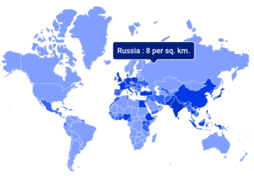
Syncfusion Flutter Maps is a data visualization library. You can use it to create a highly interactive and customizable maps widget that has features set includes tile rendering from OpenStreetMap, Bing Maps, and other tile providers.
mapbox_gl
This plugin allows developers to use Mapbox vector tiles in their Flutter apps. It allows to show embedded interactive and customizable vector maps inside a Flutter widget.
maps_launcher
This is an extension of url_launcher, which allows to open the maps application (or browser) on all platforms.
google_maps_webservice
This is a collection of tools written in Dart for connecting to Google Maps Webservices.
final geocoding = new GoogleMapsGeocoding(apiKey: "<API_KEY>");
final geocoding = new GoogleMapsGeocoding(apiKey: "<API_KEY>", httpClient: new BrowserClient());

GeocodingResponse response = await geocoding.searchByAddress("California, USA");
apple_maps_flutter
This package offers an Apple Maps widget.
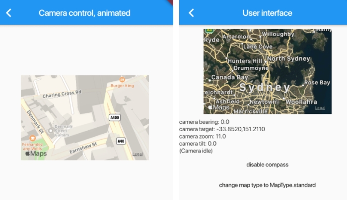
AppleMap(
  onMapCreated: _onMapCreated,
  initialCameraPosition: const CameraPosition(
    target: LatLng(0.0, 0.0),
  ),
)